Precision Aerial Surveys, Photography, and Videography in Seattle
Unrivaled Aerial Perspective for Washington Operations
For comprehensive aerial survey requirements across Washington, including advanced magnetometer and electromagnetic surveys, LiDAR data acquisition, and precise GIS mapping, Seattle Helicopter Charters provides versatile helicopter platforms. The inherent low-altitude flight and hover capabilities of helicopters are essential for collecting high-resolution data in challenging terrains. Additionally, our specialized aerial filming services integrate cutting-edge cinematography and photography technologies, facilitating everything from complex gimbal-stabilized camera setups to door-off operations for optimal handheld shot angles, ensuring superior visual documentation for all projects.

Aerial
Surveys
LiDAR, GIS Maps, FLIR, HD Video & More
Seattle Helicopter Charters provides tailored helicopter solutions for critical infrastructure inspection. This encompasses precise pipeline integrity surveys, Right-of-Way (ROW) compliance evaluations, and comprehensive transmission line patrols. We ensure the deployment of appropriately configured aircraft and skilled flight personnel, equipped with the necessary technologies to execute each project with accuracy and operational efficiency.
High Tech Results
The Top Pilots in Washington, Today's Technology... Maximum Results.
Call 206-785-9422 Now!
Seattle Helicopter Charters provides the tools needed to complete your land surveys, utilizing the right equipment to provide the aerial photos that are often needed.
Effective helicopter-based aerial surveys significantly streamline complex operations such as Right-of-Way (ROW) and site inspections, topographical data acquisition, and the capture of high-definition imagery for commercial projects throughout Washington. This method proves invaluable for precise pipeline leak detection, identifying transmission line anomalies, and detailed property assessments. Seattle Helicopter Charters custom-engineers photographic and remote sensing operations, optimizing technical and financial efficiency to deliver actionable data and conclusive results for diverse industry needs.
The operational characteristics of a helicopter, specifically its capacity for low-altitude, low-airspeed flight, make it the optimal platform for detailed aerial surveying. Unlike fixed-wing aircraft, which are generally bound by FAA Part 91 regulations requiring a minimum of 1,000 feet above the highest obstacle, helicopters can operate at significantly reduced altitudes. This distinct capability permits the close-range inspection of otherwise inaccessible or hazardous zones, providing engineers with an invaluable, otherwise unattainable perspective for critical analysis.
There is no better way to conduct your visual survey, animal population counts, soil drainage analysis, ROW inspections, pipeline and transmission line inspections, and geographical surveys.

LiDAR Imaging
Light Detection and Ranging, or LiDAR, is a remote sensing method used to examine and measure Washington topography as well as objects, like vegetation, upon it.

Infrared Imaging
Thermographic IR cameras are used to detect radiation in the long-infrared range of the electromagnetic spectrum and produce images of that radiation, called thermograms.

HD Video Gimbal Capture
Modern HD and 4K cameras can be mounted to helicopters, using the proper STCs, with a gimbal to stabilize photos & videos for detailed results.
Advanced Aerial Filming and Professional Cinematography Services
For expert camera work in the Seattle Sky
Get a Fast, free QuoteSeattle Aerial Cinematography
Seattle Helicopter Charters provides comprehensive access to professional-grade aerial cinematography resources throughout Washington. Our network integrates advanced technologies for custom production shoots, utilizing industry-standard gyro-stabilized camera mounts, including Tyler Mounts, Wesscam, Cineflex, Pictorvision, and SpaceCam. These systems are compatible with high-end specialty cameras such as Cineflex HD, RED Epic, and Arri Alexa, alongside capabilities for 3D and experimental camera setups. We support all aspects of production goals, from precise air-to-air to intricate ground-to-air compositions. Our flight personnel collaborate closely with aerial Directors of Photography and directors to achieve specific visual objectives. Specializing in helicopter platforms for both still and motion photography, Seattle Helicopter Charters facilitates a broad spectrum of media operations across Washington, encompassing feature films, television productions, documentaries, promotional videos, commercials, aerial prop integration, rapid relief work for news networks, and comprehensive coverage of historical events and major sporting competitions with a diverse selection of helicopters.
Call Us Today at 206-785-9422 for a Free Quote
Contact Us
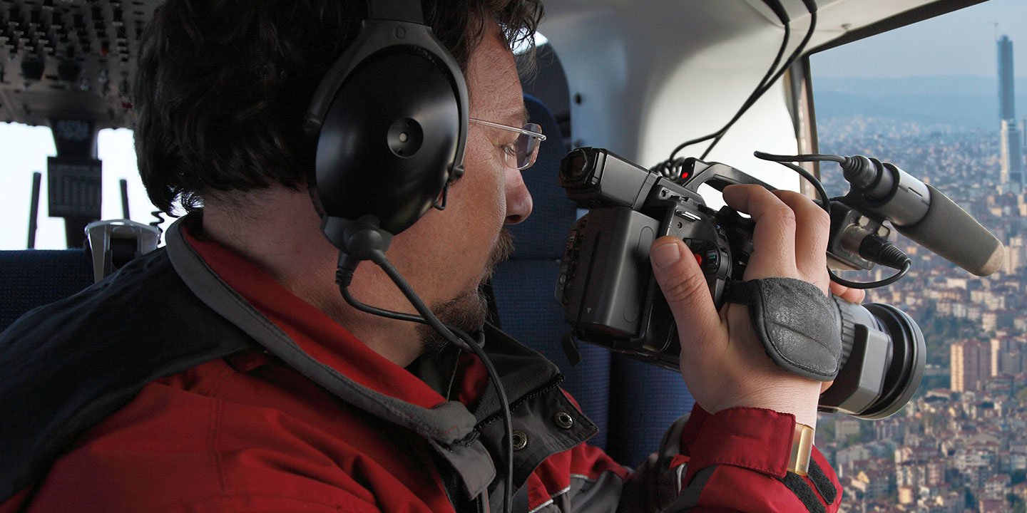
Aerial Photos
Hand-held or Mounted OpTions in Seattle
We will help you get the right equipment for your aerial photography project! Call 206-785-9422 today to get a fast, free quote.
The Most Options for Photography
Capturing the intricate details of Washington's diverse landscapes from an aerial perspective demands precision and technical capability. Our aerial photography charters are engineered to exceed professional expectations, enabling the meticulous capture of desired visual narratives. Seattle Helicopter Charters provides technically optimized photographic opportunities across Washington, ensuring access to platforms that support both door-off configurations for precision handheld projects and advanced gyro-stabilized mounts for superior image stability. We encourage inquiries regarding specific technical requirements to align equipment with project objectives.
Superior Service
Every one of our customers gets a dedicated helicopter expert to assist with flight plans, tech loadouts, production logistics, project schedules, and other demands.
Over 500 Aircraft
Our network of direct air partners extends well beyond Seattle, Washington. This allows us to offer a wide range of solutions for even the most sophisticated projects.
The Best Equipment
From high-tech sensors like LiDAR, FLIR, and GIS to HD cameras and movie production gimbals, we're here to make your job as easy as possible.